
THE ASSESSMENT OF SOME
HYDROMETEOROLOGICAL ARIDITY AND DROUGHT INDICES IN THE
EVALUAREA UNOR INDICI HIDRO-METEOROLOGICI DE ARIDITATE SI SECETA IN SUBCARPATII DE LA CURBURA SI ZONELE PERIFERICE ACESTORA
Abstract: This study tackles an interdisciplinary water resources issue, comprising one of the joint researches in Meteorology, Hydrology, Soil Science and Agronomy. Thereby, the main hydrometeorological parameters for identifying areas affected by water deficit will be discussed. Drought is one of the major natural hazards that may cause great losses to the rural community each year, due to the dependence of agriculture on water resources, especially water scarcity.
The investigated area (
Rezumat: Biroul European de Soluri administreaza Baza Europeana de Date de Soluri, care se bazeaza pe "Harta de soluri a Europei" la scara 1:1.000.000. Una din cele patru componente a acestei baze de date este constituita dintr-o serie de Reguli de Pedotransfer (RPT) care permit derivarea unor proprietati suplimentare ale solului in scopuri practice. Aceste RPT sunt bazate pe evaluari de tip expert, fiind in principal calitative. Atributele de iesire au fost selectate pe baza parametrilor de mediu necesari pentru rezolvarea unor probleme specifice.
Scopul acestei lucrari este de a prezenta o adaptare a Regulilor de Pedotransfer la nivel national, pe baza hartii de sol la scara 1:200.000. Sursele de date utilizate sunt: harta de soluri, harta materialului parental derivat din harta de soluri 1:1.000.000, datele climatice derivate din proiectul MARS, Modelul Digital al Terenului si harta utilizarii terenului LCCS. Pentru utilizarea RPT-urilor, au fost realizate cateva programe de tip macro. Iesirile sunt salvate ca fisier de tip .txt, pentru a fi legate la harta principala (de soluri sau LCCS) pentru a fi reprezentate spatial.
Rezultatele pot fi utilizate in modele de simulare a proceselor hidrologice din sol, cresterii si dezvoltarii plantelor, etc., acestea necesitand o serie de parametri noi, care nu sunt cunoscuti.
In aceasta lucrare sunt prezentate structura programelor (macro-uri) dezvoltate pentru utilizarea regulilor de pedotransfer ale JRC, precum si cateva harti ale parametrilor calculati.
Key words minimum runoff, aridity indices, drought indices, Bend Subcarpathians
Cuvinte cheie scurgerea minima, indici de ariditate, indici de seceta, Subcarpatii de la Curbura
Schimbarile care au avut loc in Romania dupa anul 1990 au condus la o noua strctura a suprafetei agricole, mult mai fragmentata, micile proprietati detinand cca 66,5% din suprafata agricola a tarii. Acestea au mai mult un rol subzistenta, prezentand o capacitate redusa de investire in sistemul de irigatii, de fertilizare a solului sau de aplicare a unor tehnologii moderne. La deprecierea semnificativa a calitatii productive a terenurilor agricole dotorata fragmentarii excessive se adauga dependenta productivitatii, in mare masura, de influenta directa a factorilor climatici. Adaptarea agriculturii la fenomene precum seceta sau ariditatea ar trebui sa se realizeze nu numai prin irigarea terenurilor, dar si prin schimbarea practicilor agricole si ale tipurilor de cultura. Spre exemplu, se apreciaza ca lipsa irigatiilor in conditiile unor secete accentuate si prelungite, cum a fost seceta din anul 2000, a condus la reducerea productiei de cereale cu 40% fata de anul precedent (xxx).
Inca de la inceput trebuie facuta distinctia intre cei doi termini, drought and aridity. Drought is a climatic phenomena, marked by a temporary and periodical anomaly, which arise from the lack of precipitation over an extended period of time. Aridity instead is a permanent characteristic of climate, associated with low rainfall regions, subjected to the frequent or continuous incidence of droughts (Subrahmanyam, 1983). Drought is one of the major natural hazards that may cause great losses to the rural community each year, due to the dependence of agriculture on water resources, especially water scarcity, during different phenophases of crop growth. A climate with high evaporation and limited precipitation leads to limited yields. During the minimum runoff periods caused by meteorological droughts, stream channels are recharged exclusively from groundwater, their flow rate being dependent on the state of aquifers depletion, as well as on the manner to which river channels intercept the water table.
Indifferent de masurile de adaptare luate in considerare, managementul agricol se bazeaza, printre alte date de intrare, si pe cunoasterea prealabaila a resurselor de apa si identificarea arealelor afectate frecvent de deficit de apa, a riscului de producere a diferitelor tipuri de seceta (meteorological, hidrologica sau pedologica) sau stabilirea gradului de ariditate a unui teritoriu.
Prezenta barajului orografic al Carpatilor creeaza un adapost topoclimatic in timpul circulatiei predominante a maselor de aer maritim din vest si continentale din est, ceea ce face ca Subcarpatii de la Curbura sa prezinte un climat mai bland, determinat si de consecintele corelate ale expozitiei sudice a versantilor. Un rol important il are foehnul, care se manifesta pe versantii adapostiti fata de circulatia aerului de vest. Acest fenomen este datorat curburii Carpatilor, masele de aer vestic umede producand precipitatii pe versantul vestic si generand efecte de foehn, pe cel estic, adapostit.
Masele de aer oceanice de pe directie vestica si nord-vestica, incarcate cu o mare cantitate de vapori de apa, intalnind bariera carpatica provoaca, prin ascensiune si racire adiabatica, caderea de precipitatii incepand de la baza versantilor pana la o anumita altitudine dupa care, saracite in vapori de apa, isi continua ascensiunea fara a mai produce precipitatii. La coborare pe pantele estice ale carpatilor masele de aer se incalzesc rezultand astfel fenomenul de foehn.
Fara efectul de foehn, climatul local al regiunii ar fi fost mai aspru (Bogdan, 2005). Ca urmare a barajului Carpatic insa, in regiunea subcarpatica exista un climat mai bland, cu contraste termice mai mici intre zi si noapte, iarna si vara, cu fenomene de iarna si inversiuni de temperatura diminuate ca intensitate, durata si frecventa, dar cu o frecventa mai mare a fenomenelor de inghet-dezghet si cu frecvente perioade calde de iarna etc. (Bogdan, Mihai, 1977, 1979; Bogdan, Niculescu, 1996). Intrucat foehnul este un vant cald si uscat, acesta determina o scadere a precipitatiilor, in schimb creste durata de insolatie si radiatia solara, care, la randul lor determina cresterea temperaturii si diminuarea frecventei si intensitatii fenomenelor de iarna, reducerea umezelii relative si aparitia fenomenelor de uscaciune si seceta (Bogdan, 2005). Un rol important il are si expozitia versantilor care fie determina o crestere a proceselor de insolatie pe versantii cu expunere sudica si sud-vestica, fie determina un adapost fata de circulatia aerului de vest pe cei cu expunere estica, situati "sub vant" (fig. 9.1).
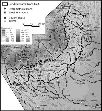
Subcarpatii de la Curbura, cu o suprafata de circa 6417 km2, prezinta o structura morfologica foarte complicata ca urmare a complexitatii geologice si a situarii acestora in vecinatatea ariei de afundare din nord-estul Campiei Romane, intr-o regiune caracterizata de o intensitate mare a manifestarilor neotectonice. Astfel, detin o pozitie aparte in cadrul unitatilor de relief, avand un caracter de tranzitie intre Carpati si campie (fig. 4.1).
The complicated structure of the Curvature Subcarpathians (ca 6,417 km2) is the result of geological complexity and position in the proximity of the north-east subsidence area of the Romanian Plain (Fig. 1).
Most
of the drainage network belongs to the
The small streams of the Vrancea Subcarpathians confluencing directly north with the Siret (the Cerecna, Zabraut, Susita and Garla Morilor) drain only 7.3% of the study area, the more important stream being the Susita.
Pentru a surprinde cat mai exact scurgerea lichida si solida, sub toate aspectele ei (medie, minima, maxima), si mai ales a diferitelor legaturi cu altitudinea, a fost utilizat un numar de maxim 68 de statii hidrometrice, situate atat in Subcarpatii de la Curbura, dar si in arealul carpatic de formare a scurgerii si in unitatea de campie. Toate aceste statii, cu exceptia a 5 statii situate in bazinul hidrografic Trotus, sunt amplasate pe rauri care traverseaza unitatea subcarpatica sau isi au izvoarele aici. Sintre acestea, 23 de statii sunt amplasate chiar in unitatea analizata, 18 in arealul montan de formare a scurgerii iar un numar de 22 statii sunt situate in campie (fig. 11.1).
Cele 45 statii care sunt amplasate in afara Subcarpatilor de la Curbura, sunt totusi majoritar situate in imediata apropiere (28 din ele sunt la o distanta de pana la 20 km iar 39 pana la 30 km, ceea ce inseamna ca sunt destul de reprezentative pentru acest areal subcarpatic - tabel 11.1).
O singura statie, Slobozia pe raul Ialomita este situata la o distanta mai mare, peste 80 km, fiind utilizata pentru a surprinde aportul raului Sarata, doar partial masurat prin statia Baba Ana pe afluentul sau Ghighiu. Asa cum s-a observat din capitolele anterioare, Sarata are un puternic caracter subcarpatic, componentele geografice ale acestui bazin hidrografic prezentand un grad mare de omogenitate.
Aceste 68 de statii (tabel 11.2) sunt utilizate mai ales pentru analiza mediilor, in cazul minimelor si a maximelor numarul lor reducandu-se substantial.
The JRC Pedotransfer Rules Database handles 41 pedotransfer rules (PTR), with an addition of other 8 PTRs, developed in the MARS program framework. A PTR looks like a table with several columns as input parameters and two or three columns as output parameters. The last two columns hold information about the author of the PTR and the updating time. Each row of the table is an "instant" of the PTR, a specific condition for that PTR. The input or output variables are described by a set of string or numeric values, interpreted in the database dictionary. For example, in fig. 1, an extract of the first PTR is shown.
|
Nr. crt |
SN1 |
SN2 |
SN3 |
TXT1 |
TXT2 |
PM11 |
PM12 |
PM13 |
TEXT |
TEXT.CL |
Auth. |
UPDATE |
|
h |
CL | |||||||||||
|
h |
CL | |||||||||||
|
h |
CL | |||||||||||
|
|
h |
CL | ||||||||||
|
h |
CL | |||||||||||
|
h |
CL | |||||||||||
|
h |
CL | |||||||||||
|
B |
l |
JJL | ||||||||||
|
B |
d |
l |
JJL |
SN1 - SN3: First, second, and third character in item SOIL;
TXT1, TXT2: Dominant and secondary surface textural class;
PM11 - PM13: First, second, and third character in item MAT1 (Dominant Parent Material);
TEXT: Dominant surface textural class, completed from dominant STU (Soil Typological Unit).
CL: Confidence level of the corresponding Pedotransfer Rule infered item
Any value of the variable
Fig. 1. An extract of the first Pedotransfer Rule - the soil textural class
The main data used in this analysis, taking into consideration the various input types, are as follows: a) the soil map of Romania, 1:200,000 scale, version 1 (1995), together with a correspondence table relating the specific Romanian soil types and the FAO 74 legend; b) the LCCS (Land Cover Classification System) map, at the scale 1:100,000; c) the soil parent material map at the scale 1:1,000,000, from FAO1MIL; d) the Digital Terrain Model SRTM-30, obtained by a resampling process from the 90 m resolution SRTM (Balteanu et al., 2010), used to compute the average slope and aspect for a soil polygon; e) the climatic data provided by the European project ATEAM, on a grid 10 x 10 km, assessed for the centre of the soil polygon, and f) the JRC Pedotransfer Rules Database.
The steps followed to achieve the goal of adjusting the JRC PTRs are:
Identifying the input data sources (maps, databases, expert information);
Gathering and preparing input data from sources (by reading data, overlaying different layers, averaging data on each polygon of a layer, using expert evaluations);
Developing specific software (a set of macros) in VBA environment;
Running the specific software;
Exporting the outputs as .txt files;
Joining the existing maps with the new .txt files in order to obtain new maps.
The flowchart of the applied procedure is shown in fig 2.
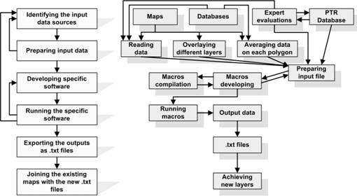
Fig. 2. The flowchart of adjusting the JRC Pedotransfer Rules to the scale of 1:200,000
The main issue was to identify the input data sources, and to adjust some of the existing data to the scale that was used in the study. There are 47 input data, many of them being parts of another input data (for example, each character of item Soil Type, each character in item PM1 - Dominant Parent Material, etc.). On the other hand, some output data from a certain PTR become inputs for other PTRs. For the soil parent material (PM), the FAO1MIL map has been used. By overlaying it with the soil layer, a full description of PM types (including the area percentage of them) for soil polygons was obtained. The main PM type for each polygon was considered as the Dominant Parent Material (PM1), while the second one was assumed to be the secondary PM (PM2). For using the climatic data, the ATEAM data has been computed for the polygon centroid. The topographical parameters (elevation and slope) have been averaged for soil polygons using Spatial Analyst from ArcView.
The first step for PTR adjusting was to identify the input data sources. Several experts rules have been developed in order to obtain the needed input parameters from the soil map at 1:200,000 scale, which has no such more information on soil as the European Soil Map at the scale of 1:1,000,000. The information about PM1 and PM2 have been obtained through overlaying procedure, as it was described previously. The Soil Map has been overlaid with the LCCS map, the outcome layer being used as input data in several PTRs. On the other hand, the climatic parameters have been computed for each LCSS & Soil polygon.
For each PTR, a macro has been developed, with several specific subroutines, as shown in fig. 3.


Fig. 3. The main structure of a PTR macro.
After running the specific macro, the outputs was saved as a .txt file and joined with the soil coverage. In fig 4, the results of the first two PTRs are shown.


Fig. 4. The first two JRC pedotransfer rules: a) Topsoil textural class, b) Limits on agricultural use.
In February 2010, a new version of Digital Soil Map of Romania has been prepared by the Soil Information Department of ICPA. The layer has been corrected taking into account a new hydrological layer based on orthophotos. Therefore, the macros and procedures developed in this paper have to be applied on this new version. The macros are still available, but the information prepared by overlaying different layers has to be computed once again.
The
JRC Pedotransfer Rules PTR, developed for a scale of 1,000,000, have been
adjusted for
Several expert rules have been used in order to obtain new information from the existing 1:200,000 soil map.
New information has been obtained also by overlaying different layers, like soil map and Parent Material map, or the soil map and LCCS map. By running the specific macros developed in this paper, several new parameters have been obtained and new maps are drawn.
In February 2010, the second version of Digital Soil Map of Romania was released, therefore, the macros and procedures developed have to be applied on this new version.
Subrahmanyam,
V. P., 1983 - Water
balance approach to the study of aridity and droughts with special reference to
|
Politica de confidentialitate |
| Copyright ©
2025 - Toate drepturile rezervate. Toate documentele au caracter informativ cu scop educational. |
Personaje din literatura |
| Baltagul caracterizarea personajelor |
| Caracterizare Alexandru Lapusneanul |
| Caracterizarea lui Gavilescu |
| Caracterizarea personajelor negative din basmul |
Tehnica si mecanica |
| Cuplaje - definitii. notatii. exemple. repere istorice. |
| Actionare macara |
| Reprezentarea si cotarea filetelor |
Geografie |
| Turismul pe terra |
| Vulcanii Și mediul |
| Padurile pe terra si industrializarea lemnului |
| Termeni si conditii |
| Contact |
| Creeaza si tu |